That Montezuma guy, he seems to have gotten around a lot in the Southwest. His name is on quite a few monuments. In reality, he never visited here, but his name was gold back in the day of exploration, and so it appears at many parks and monuments in Arizona.
In 1540, Coronado received a commission from the Viceroy of New Spain to conquer the seven cities of Cibola, discovered the year before by a priest. He took 350 soldiers and 700 native Indians with him to carry supplies. They expected to pay back the commission and become rich beyond belief with gold and jewels.
Maybe WE could find the same gold!! Probably not, but the drive was definitely worth the effort. A couple of miles down the dirt road and we spotted this sign. Uh oh ... 37 miles of bumpy gravel? How much water and food do we have???
The views were pretty gorgeous as we bumped along the dirt road. That's Mexico in the distance, but I'm not exactly sure where the border is. Usually when we are this close to the border we see lots of patrol vehicles. This time, not so much.
It's pretty desolate out there, but we did see a few small streams with water. There wasn't a single animal in sight except for one ground squirrel and a roadrunner. Dan kept driving while I was thinking we probably could have used a little more ballast in the back seat to help the tires gain a little more traction. Guess I shouldn't have started that diet again!
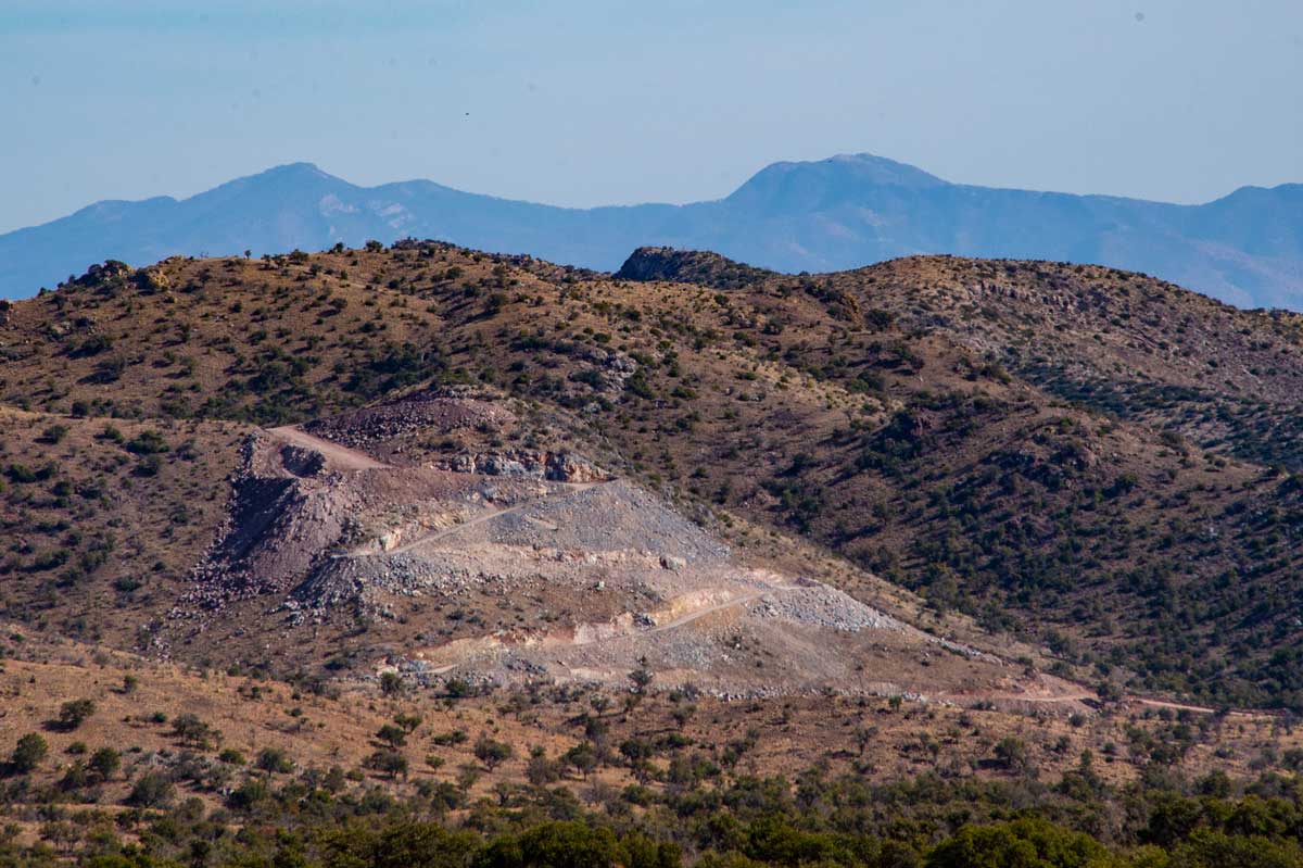
Although we thought this image showed a mine, it was actually just a road down to the border.
Although it doesn't look steep, that line to the right is the road we followed, passing maybe three trucks the entire route. You have to admit it's gorgeous on this side of the Huachuca Mountains.
At the very top of the road we arrived at Montezuma Pass. All the time we had been in the Coronado National Forest. There are many trails that head out from here, one going to the top of that mountain on the upper left. I wandered up there and spotted a Border Patrol truck in the corner of the parking lot.
Come to find out, they had just arrested an illegal carrying a backpack and heading to Sierra Vista. If you do see people wandering around in the desert, it's never a good idea to pick them up. You never know who you might run into, especially now.
Back to Coronado, off they went North in 1540 and ran into another explorer Diaz who had been sent the year before. The truth was the first explorer Marcos the priest, pretty much exaggerated his findings, but the rumor of gold and riches kept the troops headed north anyway.
They found Cibola, but none of the gold. Although archeologists have tried to follow his direct path, they have never been able to provide evidence of the trails he took.
The original idea was to name this area the Coronado International Memorial, fostering unity with Mexico, but since Mexico did not hold up their end of the bargain, it was finally named the Coronado National Memorial.
This is the view looking East where they suspect Coronado marched his troops North. Yes, that's the tiny narrow windy still gravel road heading down the mountain into the San Pedro Valley and up to Sierra Vista.
This is looking to the Southwest and Mexico below.
Coronado went on to discover the Grand Canyon and explore the Colorado River. Sadly, along the way he was responsible for the deaths of hundreds of locals. Instead of asking for food and supplies, he just killed everyone and took what he wanted. After many unsuccessful forays into unknown territory, he was badly injured when he fell from his horse. He finally died in 1554 from an infectious disease. So much for Coronado!!
As you come out of the mountains down the STILL gravel road, you can see the wall heading off into the distance. Again, don't pick up anyone you see walking down the road as cartel and drug smugglers seem to have a free rein now.
Here's a map of the route we took. We did not stop at the Visitor's Center noted here, but kept going into Sierra Vista for some dinner. The entire trip took seven hours, but that's because dinner took up almost an hour waiting for food.
It's a great trip to and over the Pass. If you have time, definitely take the long way around. As a precaution, take lots of food and water!!!


Okay, I'm hooked! I've mapped the route out. Just have to take that road trip myself. Sounds like fun and I'm close by. Great pictures.
ReplyDeleteYou will love it Doug. Hoping you don't have any snow this morning! This weather certainly is weird!!
DeleteYou definitely need to go again. Take someone with you and also make an effort to go and visit the caves, only a short drive from the visitor center. Bring flashlights. I used also a headlamp (freebie from Harbor Freight) You won't regret going!
ReplyDeleteCaves? Right up my alley Marlene. Thanks for the info. I'll definitely be going there!!!
DeleteGorgeous pictures. Pictures never show the depth or skinniness (is that a word?) of roads! Now you've got Doug going, awesome! How fun to have people to go with and enjoy! Great trip!
ReplyDeleteIt's a pretty fabulous drive in my book. That valley is HUGE, making the views even more spectacular.
DeleteWow, that sounds like quite a trip. Those switchbacks can be scary but beautiful! :)
ReplyDelete